
The third report in our Wildfire Report Series compares the publicly reported loss metrics (e.g., deaths, injuries, dollar losses and acres burned) from media and government sources for 6 named wildfires between 2016 and 2018 with the data reported by local fire departments to the National Fire Incident Reporting System (NFIRS).
Download
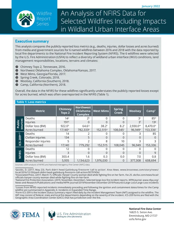
An Analysis of NFIRS Data for Selected Wildfires Including Impacts in Wildland Urban Interface Areas January 2022, 85 pagesExecutive summary
The 6 wildfires were selected by the U.S. Fire Administration (USFA) to reflect a diversity of wildland urban interface (WUI) conditions, land management responsibilities, locations, terrains and climates:
- Chimney Tops 2, Tennessee, 2016.
- Northwest Oklahoma Complex, Oklahoma/Kansas, 2017.
- West Mims, Georgia/Florida, 2017.
- Spring Creek, Colorado, 2018.
- Woolsey, California (Southern), 2018.
- Camp, California (Northern), 2018.
Overall, the data in the NFIRS for these wildfires significantly understates the publicly reported losses except for acres burned, which was often overreported in the NFIRS (Table 1).
Table 1: Loss metrics
| Metric | Chimney Tops 2 | Northwest Oklahoma Complex | West Mims | Spring Creek | Woolsey | Camp1 | |
|---|---|---|---|---|---|---|---|
| Public sources | Deaths | 14a | 2b | 0 | 0 | 3c | 85d |
| Injuries | 191e | 0 | 0 | 0 | 3f | 13g | |
| Dollar loss ($M) | 922.0h | 64.6i, j | 38.2k | 8.2l | 2,930.0m | 8,470.0n | |
| Acres burned | 17,140o | 782,333p | 152,515q | 108,045r | 96,949s | 153,336t | |
| ICS-209u,2 | Deaths | 14 | 2 | 0 | 0 | 3 | 85 |
| Civilian injuries | 134 | 5 | 0 | 0 | 0 | 0 | |
| Responder injuries | 5 | 2 | 8 | 10 | 3 | 3 | |
| Acres burned | 17,140 | 779,292 | 152,515 | 108,045 | 96,949 | 153,336 | |
| NFIRS | Deaths | 12 | 2 | 0 | 0 | 0 | 0 |
| Injuries | 3 | 0 | 0 | 0 | 0 | 9 | |
| Dollar loss ($M) | 303.4 | 1.6 | 0.3 | 0.0 | 7.0 | 0.8 | |
| Acres burned | 5,935 | 1,134,623 | 1,976,030 | 0 | 377,308 | 608,694 |
Sources: USFA analysis of NFIRS and National Interagency Fire Center (NIFC) data.
- aJacobs, D. (2017, May 23). Park didn't heed Gatlinburg firestorm ‘call to action’. Knox News. www.knoxnews.com/story/news/local/2016/12/30/park-didnt-heed-gatlinburg-firestorm-call-action/95797456/
- b Associated Press. (2017, March 7). Officials: Harper County woman died while fighting fire on her farm. Fox 25. okcfox.com/news/local/officials-harper-county-woman-died-while-fighting-fire-on-her-farm
- c National Fire Protection Association. (2019, November, December). Selected large-loss fire incident reports. NFPA Journal. www.nfpa.org/News-and-Research/Publications-and-media/NFPA-Journal/2019/November-December-2019/Features/Large-Loss/Large-Loss-incidents
- d CAL FIRE. (2019, November 15). 2018 Incident Archive — Camp Fire. www.fire.ca.gov/incidents/2018/11/8/camp-fire/
- e Jacobs, D. (2017, May 23). Park didn't heed Gatlinburg firestorm ‘call to action’. Knox News. www.knoxnews.com/story/news/local/2016/12/30/park-didnt-heed-gatlinburg-firestorm-call-action/95797456/
- f Holland, E. (2018, November 28). $6 billion in real estate destroyed in Woolsey fire: Report. Patch. patch.com/california/malibu/6-billionreal-estate-destroyed-woolsey-fire-report
- g Sernoffsky, E. (2018, November 15). Five firefighters among dozen-plus patients burned in Camp fire. San Francisco Chronicle. www.sfchronicle.com/california-wildfires/article/Five-firefighters-among-dozen-plus-patients-13396604.php
- h Ahillen, S. (2017, August 9). Tennessee mountain community getting back on its feet after devastating wildfire. Insurance Journal. www.insurancejournal.com/news/southeast/2017/08/09/460619.htm
- i Legislative Division of Post Audit. (2018). Performance audit report: Kansas wildfire management: Evaluating the adequacy of Kansas’ wildfire suppression system. State of Kansas. www.kansasforests.org/fire_management/fire_docs/Final_Report.pdf
- j Oklahoma Farm Report. (2017, March 25). Oklahoma State extension says over sixteen million dollars in losses to agriculture as a result of Northwest Oklahoma Fire Complex. Radio Oklahoma Network. www.oklahomafarmreport.com/wire/news/2017/03/01349_OSUExtensionCostEstimate03252017_112959.php#.YFOQpC2cbOQ
- k Bates, C. (n.d.). Wildfire damage assessment for the West Mims fire. Georgia Forestry Commission. gatrees.org/wp-content/uploads/2020/02/Wildfire-Damage-Assessment-for-the-West-Mims-Fire.pdf
- l Craddock, M. (2018, July 26). Property losses in Huerfano County top $8.2 million from Spring fire. World Journal. worldjournalnewspaper.com/property-losses-in-huerfano-county-top-8-2-million-from-spring-fire/
- m National Fire Protection Association. (2019, November, December). Selected large-loss fire incident reports. NFPA Journal. www.nfpa.org/News-and-Research/Publications-and-media/NFPA-Journal/2019/November-December-2019/Features/Large-Loss/Large-Loss-incidents
- n National Fire Protection Association. (2019, November, December). Selected large-loss fire incident reports. NFPA Journal. www.nfpa.org/News-and-Research/Publications-and-media/NFPA-Journal/2019/November-December-2019/Features/Large-Loss/Large-Loss-incidents
- o Badger, S. G. (2017, November, December). Large-loss fires in the United States in 2016. NFPA Journal. www.nfpa.org/News-and-Research/Publications-and-Media/NFPA-Journal/2017/November-December-2017/Features/Large-Loss-Fires-2016
- p Oklahoma Forestry Services. (2017, March 21). Fire situation report — March 21, 2017. Oklahoma Department of Agriculture, Food and Forestry. www.forestry.ok.gov/fire-situation-report-–-march-21-2017
- q U.S. Fish and Wildlife Service. (n.d.). Southeast Region Fire Division report FY2017. www.fws.gov/southeast/pdf/report/fire-report-2017-508.pdf
- r KOAA News5. (2018, September 10). Spring fire now officially 100 percent contained. www.koaa.com/news/covering-colorado/2018/09/10/spring-fire-now-officially-100-percent-contained/
- s National Fire Protection Association. (2019, November, December). Selected large-loss fire incident reports. NFPA Journal. www.nfpa.org/News-and-Research/Publications-and-media/NFPA-Journal/2019/November-December-2019/Features/Large-Loss/Large-Loss-incidents
- t National Fire Protection Association. (2019, November, December). Selected large-loss fire incident reports. NFPA Journal. www.nfpa.org/News-and-Research/Publications-and-media/NFPA-Journal/2019/November-December-2019/Features/Large-Loss/Large-Loss-incidents
- u National Fire and Aviation Management Web Applications. SIT/209 Historical [Data set]. https://famit.nwcg.gov/applications/SIT209/historicalSITdata
- 1 Losses from NFIRS-reported incidents immediately preceding and following the ignition and containment dates/times for the Camp wildfire are summarized in Appendix A: Incidents in Expanded Time Range.
- 2 Form ICS-209 is the Incident Status Summary report filed daily by the Incident Management Team (IMT) assigned to the wildfire. The IMT may consist of federal, state and local fire departments depending on the severity of the incident. ICS-209 forms are filed with the Geographic Area Coordination Center (GACC) that has jurisdiction over the fire.
For 3 of the wildfires — Chimney Tops 2, Woolsey and Camp — over one-quarter of the area affected by the fire was WUI. For purposes of this report, WUI areas are defined as census tracts where housing density is greater than 1 housing unit per 40 acres and either half the census tract is vegetation or it is within 1.5 miles of a large area (over 1,235 acres) that is at least 75% vegetated.3 Notably, the number of fire incidents reported to the NFIRS had no relationship to the share of the affected area that was WUI. In other words, wildfires with high WUI shares may be expected to have a larger number of NFIRS reports, but this was not the case (Figure 1).
3 Stewart, S. I., Radeloff, V. C., Hammer, R. B., & Hawbaker, T. J. (2007, June). Defining the wildland–urban interface. Journal of Forestry, 201-207. silvis.forest.wisc.edu/wp-content/uploads/2018/10/Stewart-et-al-JOF-2007.pdf
Within the wildfire boundaries of the Chimney Tops 2, Woolsey and Camp fires, most of the NFIRS-reported incidents were from within WUI areas (Table 2). This reinforces the principle that extra attention should be placed on planning for wildfires in WUI areas. However, in the Woolsey and Camp fires, far more incidents were reported to NFIRS from outside the wildfire boundary. Some of these incidents may have actually occurred within the wildfire boundary but lacked precise address information for accurate geocoding. Others — particularly emergency medical services (EMS) and other incidents — may have been service calls related to the wildfire.
Table 2: NFIRS incidents in WUI areas and overall for selected wildfires
| Chimney Tops 2a | Woolsey | Camp | |||||||||
|---|---|---|---|---|---|---|---|---|---|---|---|
| Incident type | In WUI | Within boundary | All incidents | In WUI | Within boundary | All incidents | In WUI | Within boundary | All incidents | ||
| Fire | 1,700 | 1,708 | 2,076 | 12 | 14 | 128 | 17 | 18 | 67 | ||
| EMS | 3 | 3 | 183 | 75 | 87 | 989 | 11 | 13 | 478 | ||
| Other | 26 | 35 | 213 | 97 | 112 | 784 | 21 | 21 | 271 |
- Sources: USFA analysis of NFIRS, NIFC and University of Wisconsin-Madison data.
- a For the Chimney Tops 2 wildfire, 1,607 incidents were geocoded within WUI areas based on their ZIP codes. More accurate location information may have placed these incidents in other locations.
This analysis compares how each of the wildfires was reported by local fire departments in the NFIRS. Each wildfire is reported quite differently:
- Chimney Tops 2: 98% of the NFIRS incidents from within the fire boundary were fires, and nearly all of these were exposure fires from a natural vegetation fire. There were nearly 2,500 NFIRS reports for this wildfire from over 50 different fire departments. Most of the exposure fire reports were identical except for the amount of property loss.
- Northwest Oklahoma Complex: Similar to Chimney Tops 2, 96% of the NFIRS incidents from within the fire boundary were fire incidents, and this wildfire also included a significant number of exposure reports. While there were fewer reports than Chimney Tops 2 overall (330 total) from a similar number of fire departments, they did not complete the optional fields in the Fire module to the same degree. Also, “property loss” was frequently left blank.
- West Mims: Most of the fire boundary was within the Okefenokee National Wildlife Refuge, under the jurisdiction of the U.S. Fish and Wildlife (FWS) Service. As such, there were only 2 NFIRS reports for this fire from within the fire boundary. Outside the fire boundary, the Fire module was used by local fire departments to report additional information about a number of fires despite the fact that a majority of those fires were natural vegetation fires where the Wildland Fire module could have been used.
- Spring Creek: The Spring Creek fire had the fewest NFIRS reports among the 6 wildfires. Portions of this fire occurred in areas managed by the Bureau of Land Management (BLM), which does not contribute data to the NFIRS. It also appears that a portion of this fire fell within the jurisdiction of a nonreporting local fire department, where most of the damaged and destroyed structures were located. In addition, all the fires that were reported to the NFIRS for the Spring Creek wildfire used the Wildland Fire module.
- Woolsey: The primary responsibility for combating fires in California is divided between federal, state and local authorities based on geographic area. A significant portion of the area affected by this wildfire (including WUI areas) was outside local direct protection areas. Only 7% of the NFIRS incidents recorded for the Woolsey fire were fires, including 1 natural vegetation fire where 616 buildings were involved. Only 44 structure or mobile property used as fixed structure fires were reported in NFIRS. The majority of incidents for the Woolsey fire in NFIRS were EMS, Good Intent and Service Calls, including 248 incidents that were canceled en route.
- Camp: Like the Woolsey fire, much of the affected area was outside the local direct protection area, including large WUI areas. One-third of the NFIRS incidents from within the wildfire boundary were fires, with a significant number of EMS and Service Call incidents. Public reports state that 85 lives were lost in the Camp fire, and that nearly 19,000 structures were damaged or destroyed. There are only 8 NFIRS reports for fires in structures or mobile property used as fixed structures associated with the Camp fire, and only 2 of those occurred within the wildfire boundary. No NFIRS reports list any fatalities.
Based on this analysis, it is recommended that the USFA provide clear guidance to local fire departments regarding how to report incidents that are related to wildfires. With the current NFIRS form, it appears that there are 2 options listed below. Neither option, however, adequately addresses the challenges of multijurisdictional response and data from NFIRS nonreporters.
Option 1
Using the Wildland Fire module, a department can report the wildfire as a natural vegetation fire and indicate how many buildings were involved in the fire. It can report property and contents losses as well as deaths and injuries in the Basic Incident module. It can specify location information using the U.S. National Grid. This approach, however, cannot capture vehicle, nonbuilding structure or mobile property used as fixed structure fires, and it does not capture any granular detail about those fires.
Option 2
Using the Fire and Structure Fire modules, a department may report a natural vegetation fire and exposure fires for each structure or vehicle that is damaged by the wildfire. This approach allows local departments to capture detailed information by completing an NFIRS report for each instance of damage. However, this is a considerable amount of data to collect and enter. It also strains the understanding of NFIRS as a system used to record information about incidents to which a fire department responded. If a department was able to respond to the natural vegetation fire but was unable to make any effort to combat exposure fires, it is unclear whether the department “responded” to the exposure fires or not.
USFA should consider the data it wants to collect regarding wildfires and determine which of the approaches above comes closest to its goals.
Recommendations include:
- Define a new NFIRS form that captures the most salient details for each property affected by a wildfire (e.g., incident type, property use, property and contents loss, location, wildfire perimeter, casualties, and selected data elements from the Fire module) as an appendix to the Wildland Fire module (augmenting the Buildings Involved field).
- Consider using the Special Study field as a way to denote which NFIRS incidents are related to named wildfires and should encourage the use of the U.S. National Grid as a way of identifying location, regardless of whether street address information is available.
This analysis revealed that none of these 6 wildfires were thoroughly reported to the NFIRS. Discrepancies between the loss metrics reported by the media and those in NFIRS are significant. While some of this discrepancy can be explained by the role of NFIRS nonreporters, there are also issues with the comprehensiveness of the NFIRS reports that were submitted. Local fire departments appear to follow different protocols for using NFIRS (e.g., reporting exposure fires, choosing between the Fire and Wildland Fire modules, and completing optional data elements). USFA guidance on the best practices for collecting wildfire-related data (accompanied, if necessary, by changes to the NFIRS itself) could improve how data is captured for future wildfires.